THE GREAT SAN FRANCISCO EARTHQUAKE
19O6-1945
“The great San Francisco earthquake of 1906, on the San Andreas fault, with a magnitude of 8.3 on the Richter scale. It is the deadliest quake in the history of the Bay Area, with a human toll of 700 people. Surface fault ruptures extended for 267 miles, with displacement of up to seven yards .” [1]

Figure 1: Damaged buildings from the 1906 San Francisco earthquake [2]
THE EARTHQUAKE'S IMPACT
After the 1906 earthquake and fire in San Francisco, 150,000 people came to Oakland and approximately 2000 refugees settled in Chinatown. Because of the population boom Fruitvale, Melrose, Elmhurt, and areas between Brooklyn and San Leandro were annexed and now are part of Oakland. Oakland’s land mass increased from 22.9-60.25 square miles. By 1910, Oakland population doubled than in the 1900(150k people).
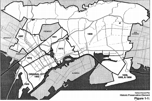
Figure 2: Original Oakland and areas that were annexed throughout the years[3]
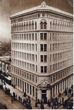
Figure 3: First National Bank of Oakland 1907-1908 [4]
Following the earthquake, North, East and West Oakland were revamped. In 1903, Capitalist Francis Marion Borax Smith solidified the independent streetcar and electric train routes in the Alameda – Contra Costa Transit District which is the former Key Route. Smith later founded the Realty Syndicate which was a development company. The company extended streetcar lines into Piedmont Pines and Oakland Hills. 1906, Smith built the Claremont Hotel, a resort attraction. Realty Syndicate failed in 1929 but contributed some things to early development such as Idora Park, Havenscourt Boulevard, and palatial Spanish style houses in Piedmont Pines. Many of Oakland’s tall buildings were a result of the Earthquake and population boom which includes Union Bank Building(1904-05), First National Bank of Oakland Building(07-08), Oakland Bank of Savings Building(07-09), Security Bank Building(11-12), Oakland Hotel(10-12), and Federal Realty Building (13-14). With the construction of these tall buildings, Oakland became a city instead of a small town.
Frank Mott was Oakland’s mayor for ten years since 1905(1905-1915) before stepping down. Following the earthquakes and fires, Mott reorganized the police and fire departments. Mott was very concerned with the city services and built water and sewer lines, and installed street lighting. Mott also led improvements parks as this was a new idea coming to the United States. Frank Mott got together with a man named Mumford Robinson, a man known for planning and making cities beautiful (civic improvements). Robinson would eventually come up with a plan for Mott in May of 1906. This plan was called the Robinson plan. The Robinson plan dealt “mainly with the need for parks and boulevards. Much of the plan discussed creation of large parks connected by drives and parkways”[5]. Two specific locations that Robinson called the need for parks were Lake Merritt and Indian Gulch. The land around Lake Merritt was to be used for a park and a boulevard to be built around the lake. Indian Gulch would be turned into a 300 acre park and would be used for “picturesque and romantic walks and drive”. A park way would then come out of Indian Gulch that would connect to Dimond Canyon and later East Oakland. The Robinson plan also called for some minor improvements for urban life such as “regulating billboards, removing wires over streets, improving street lighting and replacing wooden street curbs for stone or concrete”. According to the Robinson plan, it did not have any plans for the housing needs in Oakland which is surprising because of the large population boom from the earlier earthquakes and fires. The Robinson plan focused mainly on civic improvements which included the improvement of sidewalks, fences, and parks.
Frank Mott was Oakland’s mayor for ten years since 1905(1905-1915) before stepping down. Following the earthquakes and fires, Mott reorganized the police and fire departments. Mott was very concerned with the city services and built water and sewer lines, and installed street lighting. Mott also led improvements parks as this was a new idea coming to the United States. Frank Mott got together with a man named Mumford Robinson, a man known for planning and making cities beautiful (civic improvements). Robinson would eventually come up with a plan for Mott in May of 1906. This plan was called the Robinson plan. The Robinson plan dealt “mainly with the need for parks and boulevards. Much of the plan discussed creation of large parks connected by drives and parkways”[5]. Two specific locations that Robinson called the need for parks were Lake Merritt and Indian Gulch. The land around Lake Merritt was to be used for a park and a boulevard to be built around the lake. Indian Gulch would be turned into a 300 acre park and would be used for “picturesque and romantic walks and drive”. A park way would then come out of Indian Gulch that would connect to Dimond Canyon and later East Oakland. The Robinson plan also called for some minor improvements for urban life such as “regulating billboards, removing wires over streets, improving street lighting and replacing wooden street curbs for stone or concrete”. According to the Robinson plan, it did not have any plans for the housing needs in Oakland which is surprising because of the large population boom from the earlier earthquakes and fires. The Robinson plan focused mainly on civic improvements which included the improvement of sidewalks, fences, and parks.
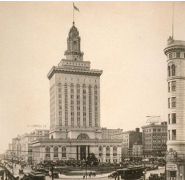
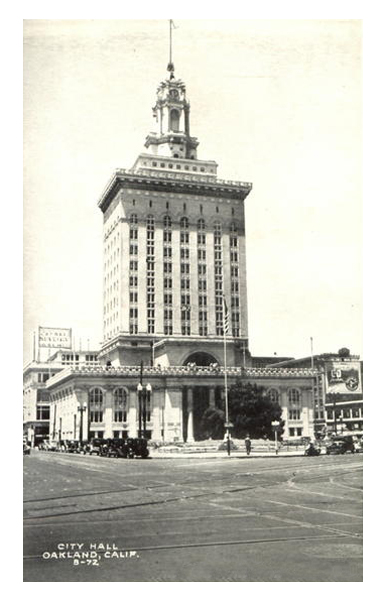
Figure 4: City Hall in 1912 [6]
|
This can be seen in 1907 when a $992,000 bond was approved by voters to buy ten pieces of property for the purpose of civic improvements. Five of those ten properties were for park purposes. The city of Oakland was in favor of building parks because they believed that parks gave cities an economic advantage by attracting immigrants to their city, brought communities together, and improved the market value of nearby homes. For the next couple of years, the construction of parks commenced and in 1908 the city of Oakland approved another $125,000 park bond. From 1907 – 1915, thirteen playgrounds and twenty seven school yard playgrounds were built. For all of this to happen, Mott had a lot of support from different areas. One strong area of support was business organizations which included the Chamber of Commerce and the Santa Fe improvement association.
|
In 1909, Mott and Oakland residents approved $1.15 million dollars for the construction of a new city hall. This city hall would be eight stories high and would be revolutionary for this city at the time of construction. City hall was completed in three years.
After the construction of city hall, the city of Oakland wanted to construct a Civic Auditorium. The bond for this building would be approximately $500,000. This building was essential because it was thought to bring “conventions, capital and business to Oakland”. Another reason that they thought the building was essential to establish Oakland as up to par with other progressive cities. They would later realize that a building of this stature could not be built on a $500,000 budget and had another vote asking for $500,000 to finish the building.
After the construction of city hall, the city of Oakland wanted to construct a Civic Auditorium. The bond for this building would be approximately $500,000. This building was essential because it was thought to bring “conventions, capital and business to Oakland”. Another reason that they thought the building was essential to establish Oakland as up to par with other progressive cities. They would later realize that a building of this stature could not be built on a $500,000 budget and had another vote asking for $500,000 to finish the building.
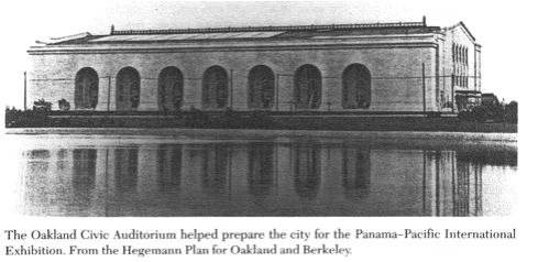
Figure 5: Oakland’s Civic Auditorium[7]
Later in 1915, California passed a city planning enabling act which allowed cities to establish city planning commissions. This also allowed the ability to zone areas for “residential, commercial and industrial use”. Because of this shift into zoning, the city plan had also shifted away from its original civic improvements of parks and streets. Zoning was usually initiated by real estate and home owners who wanted to protect their property values.
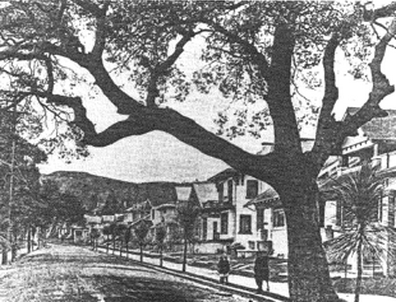
Figure 6: Standard Homes in respect to the Robinson Plan[5]
INDUSTRIAL DEVELOPMENT IN 1900S
1910, Oakland gained control of the waterfront which led into port development. Because of critical geographic positioning of the extensive rail network, and the expanding port, it made Oakland one of the largest industrial and warehouse centers. Oakland was called the “Detroit of the West” because of several automobile assembly plants [7]. The Durant Motor company still exists from the 1900’s but is now used for other things. Some aesthetically pleasing buildings are the Mutual Stores and Warehouse Complex which can be seen on East 14th Street. These buildings were designed with a Beaux Arts Spanish Renaissance style. Around 1920 was when Oakland experienced its boom in economy, commerce, and real estate.
TRANSPORTATION
Between the earthquake and WWII was known as the industrial age for Oakland. Oakland was the “Detroit of the West” and because of this, the automobile was the popular mean of transportation. The construction of tunnels, streets, and bridges allowed for the development of automobile travel. These construction sites include Stockton Street, Twin Peaks, Sunset streetcar tunnels(1914-1927), San Francisco-Oakland Bay Bridge(1936) and the Golden Gate Bridge (1937) which linked Oakland to East and North Bay. Another important transportation improvement is thanks to the Southern Pacific Railroad Bayshore bypass(1908) which connected San Bruno Mountain to the Peninsula. The Bay Bridge allowed automobiles and the Key System interurban trains. The transportation improvements brought different communities throughout the bay together. In 1948, San Francisco’s Traffic Plan proposed an idea of constructing eight freeways across San Francisco and a second bridge to respond to the traffic from the resulting automobile boom. As a result of the automobile boom, parking became a burden because of the lack of parking construction.

Figure 7: Chevrolet Factory output 1917 [8]
WORKS CITED_____________________________________________________
- Earthquakes Hazards Program. US Geological Survey. Accessed March 4, 2013. http://earthquake.usgs.gov/regional/nca/qmap/
- Earthquakes Hazards Program.
- Blackford, M. G. (1993). City Planning in Oakland and Los Angeles. The Lost Dream Businessmen and City Planning on the Pacific Coast, 1890-1920 (pp. 63-81). Columbus: Library of Congress Cataloging.
- Oakland’s First National Bank. YesterYear Once More. Retrieved March 4, 2013. http://yesteryearsnews.files.wordpress.com/2010/05/first-national-bank-oakland-19111.jpg?w=450
- Blackford. 1993. Oaklanders wanted a city of tree-lined streets and single –family houses. From the Robinson Plan for Oakland. Accessed March 4, 2013. https://ohiostatepress.org/Books/Complete%20PDFs/Blackford%20Lost/Blackford%20Lost%205.pdf
- Oakland City Hall 1920. Route40. Accessed March 4, 2013.http://www.route40.net/images/postcards/ca-oakland-city-hall-c1920.jpg
- Blackford. 1993. The Oakland Civic Auditorium helped prepare the city for Panama – Pacific International Exhibition. From the Hegemann Plan for Oakland and Berkeley. Accessed March 4, 2013. https://ohiostatepress.org/Books/Complete%20PDFs/Blackford%20Lost/Blackford%20Lost%205.pdf
- One day’s output at Chevrolet factory. Hemmings Daily. Accessed March 4, 2013. http://blog.hemmings.com/index.php/2010/08/18/found-earliest-photo-of-chevrolets-oakland-plant
